How to read structure for sturgeon on the Fraser
The vastness and sheer power of the Fraser River can feel incredibly intimidating when you're trying to locate one of its most legendary inhabitants: the white sturgeon. It's easy to feel lost, drifting over miles of water, wondering where these colossal fish might be hiding in such a massive system. But don't worry, you're not alone in that feeling. The secret to consistent sturgeon success on the Fraser often lies not just in your bait or tackle, but in your ability to 'read' the river itself, understanding the underwater structure that these magnificent creatures call home. This comprehensive guide will break down exactly how to interpret the Fraser's nuances and pinpoint those prime sturgeon holding areas.
Understanding the Fraser River's Dynamic Environment
The Fraser River isn't just a body of water; it's a living, breathing ecosystem with constant changes in current, depth, and bottom composition. White sturgeon, being ancient and highly adapted predators, rely heavily on these environmental factors to find food, conserve energy, and stay safe. To truly understand how to read the structure for sturgeon, you first need to grasp the fundamental forces at play within this mighty river.
The Influence of Current and Eddies on Sturgeon Behavior
The Fraser's current is often deceptively strong, and it plays a huge role in where sturgeon choose to position themselves. These fish are large, but they're also smart; they don't want to fight a heavy current all day long if they don't have to. Instead, they'll seek out areas where the current is broken or slowed, creating pockets of calmer water where they can rest and ambush prey without expending excessive energy. Think of these as natural "rest stops" or "dining rooms" for sturgeon.
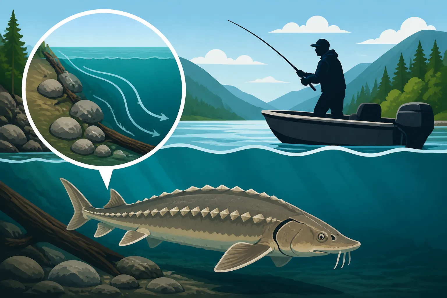
These current breaks often manifest as eddies, which are circular currents of water moving contrary to the main flow. Eddies can form behind large obstacles like submerged logs, rock formations, or even along sharp bends in the river. Sturgeon will often sit on the edge of these eddies, facing upstream, allowing the main current to deliver food directly to them. The seam where the fast water meets the slow water is a critical feeding lane. Observing the surface of the water for boils, slicks, or changes in texture can often indicate these crucial current breaks below.
Identifying Food Sources and Bottom Composition
Sturgeon are primarily bottom feeders, so what's on the riverbed is just as important as the depth or current. The Fraser is rich with potential food sources, from salmon carcasses during the fall runs to lamprey, eulachon, and various benthic invertebrates. Areas where these food sources accumulate are naturally going to be more attractive to sturgeon. This often correlates with softer bottoms – silty, sandy, or gravelly areas where prey can hide or where dead salmon settle.
Harder bottoms, like solid rock or compacted clay, can also hold fish, especially if they create significant changes in depth or current. However, in many parts of the Fraser, sturgeon prefer areas with a softer substrate that allows them to "vacuum" up food more easily. Over time, experienced anglers develop a feel for the bottom composition through their fishing line – a distinct "thump" for hard bottom versus a "mushy" feel for soft silt. Knowing what to look for can drastically narrow down your search, especially when you're trying to figure out how to read structure for sturgeon on the Fraser.
Key Types of Sturgeon Holding Structure
Now that we understand the river's dynamics, let's dive into the specific types of underwater structure that consistently attract and hold Fraser River sturgeon. These aren't just random spots; they are strategic locations that offer sturgeon everything they need to thrive.
Deep Holes and Scour Channels
Deep holes are perhaps the most iconic sturgeon holding structure on the Fraser. These are depressions in the riverbed where the water is significantly deeper than the surrounding areas. They can be created by powerful currents eroding the bottom over time, often found on the outside bends of the river, downstream of major obstacles, or at the confluence of tributaries. Sturgeon love deep holes because they offer refuge from strong currents, provide thermal stability (cooler water in summer, warmer in winter), and act as collection points for food washing downstream.
Scour channels are similar but can be longer and narrower, often running parallel to the main current or along the edge of a sandbar. These channels provide protected travel lanes and ambush points. When you're looking for Lower Fraser River Sturgeon Fishing opportunities, these deep pockets are often the first place guides will check. Locating these on your sonar (fishfinder) is key; you're looking for a sharp drop-off followed by a relatively flat, deep bottom. However, it's not just about finding the deepest spot; it's about finding a deep spot that has an active feeding lane or a current break nearby.
Drop-Offs and Ledges
Drop-offs and ledges are essentially underwater cliffs or steep inclines where the riverbed suddenly plunges to a greater depth. These are fantastic structural elements for sturgeon because they provide a vertical ambush point. Sturgeon can sit at the base of the drop-off, or even partway up, waiting for food to tumble over the edge from the shallower water above. This also offers them a quick escape route to deeper water if threatened.
These features are particularly effective when they're combined with other elements, such as a current seam running along the top or bottom of the ledge, or if there's a softer bottom material at the base where food collects. Imagine a sturgeon nestled right at the bottom of a steep shelf, where the current slows just enough to allow bits of food to settle. This is a classic scenario for a successful catch. These types of features require careful attention to your sonar, as they can sometimes be subtle but incredibly productive.
Current Seams and Confluence Points
Current seams, as mentioned earlier, are the demarcation lines where fast-moving water meets slower water. These are dynamic feeding zones. Sturgeon will sit in the slower water, positioned to grab anything that drifts by in the adjacent faster current. You can often see these seams on the surface as lines of debris or changes in water texture, but the most productive seams are often created by underwater features.
Confluence points, where two rivers or a major tributary meet the main Fraser, are super high-percentage areas. The mixing of currents creates turbulent water, deposition of sediment, and often forms pronounced deep holes and current seams. More importantly, these areas act like a funnel, concentrating food and migrating fish. For instance, knowing when Chinook Salmon Migration Patterns in BC are active can highlight confluence points where sturgeon will gather to feast on eggs and carcasses. The constant influx of new water and nutrients makes these natural larders for sturgeon.
Tools and Techniques for Identifying Structure
Reading the river for sturgeon structure isn't always about what you can see; it's often about what you can't. Modern technology and astute observation skills are your best friends in decoding the Fraser's underwater secrets.
The Indispensable Role of Sonar and GPS
A good quality sonar unit (fishfinder) is absolutely non-negotiable for serious Fraser River sturgeon fishing. This technology allows you to "see" the underwater world, revealing depths, bottom contours, drop-offs, and even the fish themselves. Look for units with down-imaging and side-imaging capabilities, as these provide incredibly detailed views of the riverbed. When scanning, pay close attention to sudden changes in depth, the shape of the bottom (is it flat, rocky, silty?), and any suspended marks that might indicate fish. Many reputable brands offer excellent sonar units, and you can often find a wide selection of models and accessories on Amazon.
Pairing your sonar with a reliable GPS is equally important. Once you find a productive piece of structure – a promising deep hole or a sharp drop-off – mark it as a waypoint on your GPS. This allows you to return to that exact spot precisely, even in strong currents or low visibility. Building up a library of these waypoints over time is like creating your personal treasure map of the Fraser. It's not enough to just see structure; you need to be able to find it again and position your boat correctly.
Reading the Water's Surface and Subtle Clues
While technology is fantastic, never underestimate the power of simply looking at the water. The surface can tell you a surprising amount about what's happening below. Look for:
- Current breaks and seams: As mentioned, lines of debris, changes in water color, or differences in the ripple pattern can indicate where fast and slow currents meet.
- Eddies and boils: Swirling water or localized upwellings can point to submerged obstacles or significant depth changes creating an eddy.
- Debris lines: Accumulations of leaves, twigs, or foam often gather along current seams and in eddies, showing where fish might be resting and feeding.
- Bird activity: If you see gulls or other fish-eating birds diving in a particular spot, it's a good sign that baitfish are congregating there, which in turn can attract sturgeon.
These visual cues are often your first hint that something interesting is happening beneath the surface, prompting you to investigate further with your sonar. Combining keen observation with your tech tools gives you a powerful advantage when trying to read structure for sturgeon on the Fraser.
Interpreting River Maps and Charts
Before you even launch your boat, studying detailed river maps and bathymetric (depth) charts of the Fraser can give you a significant head start. These resources often highlight major river features, historical channels, and approximate depths. While the Fraser is constantly changing, these maps provide a foundational understanding of the general layout of its structure.
Publicly available navigation charts for the Fraser River, or even detailed satellite imagery, can reveal major bends, islands, and areas where erosion is likely to create deep holes. Look for areas where the river narrows, where tributaries join, or where there are significant changes in the shoreline. These are all indicators of potential underwater structure. Overlaying this information with your on-the-water sonar readings allows you to create a comprehensive mental picture of the sturgeon's world. This preparation is a crucial step for anyone wanting to effectively learn how to read structure for sturgeon on the Fraser.
Fishing Strategies Based on Identified Structure
Finding the structure is only half the battle; the other half is knowing how to effectively fish it. Your approach will change depending on the type of structure you've located and the conditions of the river.
Anchoring and Positioning Over Deep Holes and Drop-Offs
When fishing deep holes or along distinct drop-offs, proper boat positioning is paramount. You want your bait to be presented right in the sturgeon's feeding zone. This usually means anchoring upstream of the target structure, allowing your bait to drift naturally into the hole or along the base of the drop-off. For the immense power of the Fraser, you’ll need a robust anchor system. Most anglers use two anchors, one off the bow and one off the stern, to ensure the boat remains stable and precisely positioned in the current.
Once anchored, you'll cast your bait rig (often a heavy lead weight with a short leader and a robust hook) upstream and allow it to settle into the strike zone. The goal is to keep your bait stationary on the bottom in the prime feeding lane. This might mean adjusting your anchor lines or making small casts to ensure your bait isn't being swept away by stronger currents nearby. Understanding Best rig for bottom fishing for sturgeon is crucial here, as a well-tied rig will resist tangles and present your bait effectively.
Targeting Current Seams and Eddies
Fishing current seams and eddies requires a slightly different approach. Here, you're looking to place your bait right on the edge where the fast water meets the slow, or within the calmer water of the eddy where sturgeon are resting. This can sometimes be achieved by anchoring, similar to deep holes, but often involves more precise casting to hit the seam.
Another effective technique for these dynamic areas is known as "bar fishing" or "trot lining" if conditions allow. This involves casting your bait out and allowing it to drift naturally along the current seam, mimicking a piece of food being carried downstream. This can be done while slowly motoring upstream to keep your bait in the sweet spot for longer, or by anchoring and casting repeatedly into the same seam. Remember that sturgeon in these areas are often facing upstream, ready to intercept anything edible that the current brings.
Adjusting to River Conditions and Tidal Influence
The Fraser River is influenced by tides, especially in its lower reaches. This tidal push can drastically change current speeds and even water levels, affecting how sturgeon position themselves on structure. During an incoming tide, the current often slows or even reverses in some areas, and fish might move up onto shallower flats adjacent to deep structure. On an outgoing tide, currents intensify, and sturgeon will usually retreat to deeper, more protected areas or tighter to current breaks. Checking BC Fishery Notices and In-Season Closures, Explained can also provide critical up-to-date information on river conditions.
This means your strategy for reading and fishing structure isn't static; it needs to be adaptive. What works at low tide might not work at high tide. Observing how the current changes throughout the day and adjusting your position accordingly is a mark of an experienced sturgeon angler. You might find sturgeon scattered across a flat on a slack tide, but concentrated heavily in a deep hole during a strong outgoing current. Flexibility and keen observation are your best assets on the Fraser.
Here's a quick reference table to help visualize different structural elements:
| Structure Type | Why Sturgeon Love It | How to Identify | Typical Fishing Approach |
|---|---|---|---|
| Deep Holes / Channels | Shelter from current, food collection, thermal stability, security | Sonar (sharp drop-offs, deep flat bottom) | Anchor upstream, cast into hole, keep bait on bottom |
| Drop-Offs / Ledges | Ambush points, current breaks, quick escape route | Sonar (vertical changes in depth, contour lines) | Anchor at base or top, let bait roll/settle along face |
| Current Seams | Food delivery lane, energy conservation zone | Visible surface changes, sonar (depth changes) | Anchor in slow water, cast into seam, drift fish or hold bait |
| Confluence Points | Concentrated food, varied currents, often create deep holes | Maps, visible merging currents, sonar | Anchor carefully, fish multiple depths/currents, explore |
| Submerged Obstacles | Current breaks, cover, ambush points | Sonar (irregular bumps, strong returns) | Anchor upstream, fish tight to the structure's leeward side |
Remember, learning how to read structure for sturgeon on the Fraser River is a journey, not a destination. Each trip out will teach you something new about this incredible river and its magnificent fish. Embrace the challenge, enjoy the process, and soon you'll be decoding the Fraser like a pro.
Disclaimer
The information provided in this guide is for general informational purposes only and is not a substitute for official regulations. Fishing rules, seasons, and licensing requirements in British Columbia can change frequently. Always consult the most current BC Freshwater Fishing Regulations Synopsis, BC Tidal Waters Sport Fishing Guide, and relevant Fishery Notices before heading out on the water. Ensure you have all necessary licenses, including your British Columbia Fishing License Guide for 2026 and any required stamps.